The country of Haiti is located on the island of Hispaniola. It is adjacent to the Dominican Republic, and as a result is surrounded by water on 3 sides. With a land troubled with natural hazards, it is only natural that Coastal Hazards also pose a threat here as well. Coastal hazards come in many forms, be it tsunamis, storm surges from tropical cyclones, and rip currents or any other strong coastal current. But one issue that poses a threat for Haiti is the rise of relative sea level. Erosion along the coast has influenced the movement of the shoreline, that is already being uplifted by the constant earthquakes the country has experienced. In a story from 2010, after the massive 7.0 earthquake that struck the capital, there were pictures from the drastic difference in relative sea level. You are able to see the top of one tree that did not go under in reference to the white structure highlighted in yellow. It was believed it was also so dramatic in the fact there might have been some kind of underwater mass wasting that occurred, which is not uncommon during earthquakes. The country is already classified as a high coastal flood hazard zone, and it is easy to see why.
Droughts are by definition an extended period of unusually low precipitation that produce a temporary shortage of water for people, other animals, and vegetation. Droughts threaten people with malnutrition or death if it causes their crops to fail. Although they normally are reason for widespread famine, the worldwide food distribution system is able to prevent this from occurring. The problem with droughts is that they normally overstay their welcome. The Caribbean Drought occurred from early 2015 to late 2017 and affected 15 countries. In 2015, the spring season of cultivation which is responsible for 60% of Haitian natural production, recorded 80% losses in what is supposed to be the most productive of Haiti's three agricultural seasons. Cattle reportedly died in large numbers as well, straining food supply further. The duration of the drought threatened the situation of 3.8 million food-insecure people. In mid 2016, only 30% of the allocated funds from humanitarian support was received, and no real improvement was reported until late 2016. That is until Hurricane Mathew struck a blow to the country in distress, and further increased the levels of food insecurity. This caused the need emergency food assistance to remain high in the country until late 2017.
What is mass wasting? More commonly known as its less technical term landslides; it is the downslope movement of earths materials. It is often a rapid movement of soil or rock in a coherent mass, such as a rockfall or avalanche. This happens as a natural phenomena, normally due to gravity and possibly the combination of some sort of triggering event such as an earthquake. Human activity also can cause the rate of landslides to increase, ranging from urbanization to simply natural resource use. Timber harvesting is among one of the many reasons associated with landslide erosion. In 2010, a devastating earthquake struck Haiti and caused landslides throughout most of the country. The United States Geological Survey compared satellite imagery from before and after the earthquake, and were able to map 23,567 different landslides that occurred that day. The earthquake was the triggering event, but the human activity could have also been to blame for that ridiculous number. For a long time, Haitians have burnt trees for fuel, charcoal is responsible for almost 75% of its domestic fuel. This has led to widespread deforestation around the entire country, so bad in fact that it is the one of the most deforested countries in the world. This makes the area high risk for landslides and flooding. I wish there was some sort of system in place that the country was implementing to prevent or at least warn citizens about this threat that looms over them, but eight years after this quake, I haven't been able to find evidence of that happening in this country.
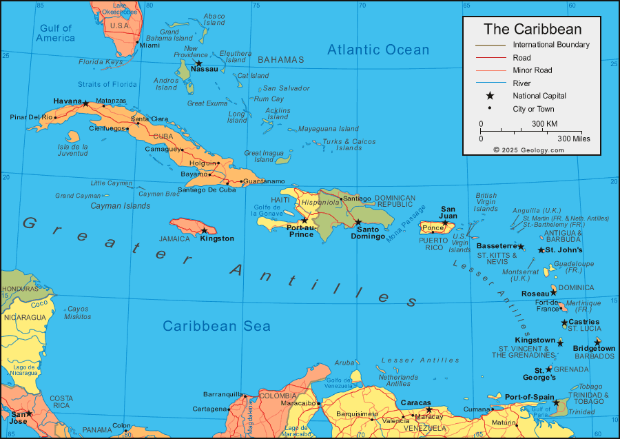
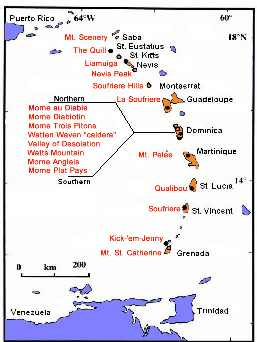
Although Mother Nature and Haiti have a very close relationship, where they share almost every natural hazard known to man, from earthquakes to tsunamis as I have covered before, Haiti although being near several subduction zones on the Caribbean plate, has not actually had volcanic activity for millions of years. The entire island of Hispaniola, that Haiti shares with the Dominican Republic, has no active volcanoes. However, as I said before, being near so many subduction zones, the possibility of a volcano forming in the future is more than likely. Most of the volcanic activity that occurs on the Caribbean is in the Lesser Antilles, where as Hispaniola lies in the Greater Antilles as shown below.
Following the 7.0 earthquake that hit Haiti in 2010, or the Goudougoudou as known by the local populace, the USGS stepped in to provide more support and set up the countries first ever national seismic network in Haiti. Also, more recently, the International Code Council, a nonprofit organization responsible for creating stronger buildings that can withstand sizable earthquakes, pledged to help the Haitian's with access to their plans and professionals to aid in the rebuilding process. However earthquakes are not the only natural hazard this country is vulnerable to, which complicates and draw out the reconstruction of this country.
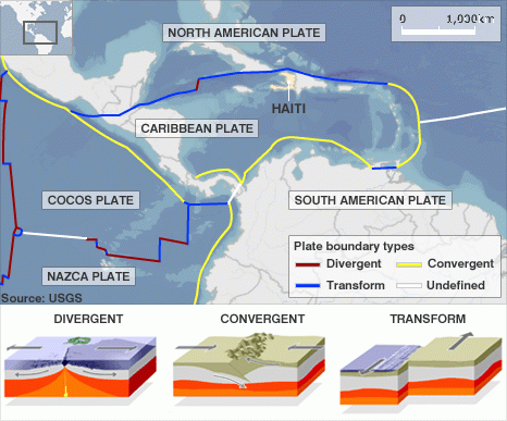
Haiti sits on a border of the North American plate and Caribbean Plate. It nearest a transform plate boundary, so as the North American plate moves west, the Caribbean plate moves east which causes a lot of friction that is unleashed as high magnitude earthquakes. It is also due to the strike-slip fault systems that run through northern and southern Haiti. A recent example is of the 2010 Magnitude 7 earthquake that tore apart its nation's capital and killed over 90,000 people.