Saturday, December 8, 2018

Haiti Final Hazards Report


        The second largest island in the Caribbean, located in-between Puerto Rico and Cuba lies the island of Hispaniola, an island that the Republic of Haiti shares with the Dominican Republic. These two countries however could not be more opposite each other, as Haiti struggles with being the poorest country in the western hemisphere, meanwhile the DR continues to be prosperous and thriving. Not only are Haiti’s problem political and economic, but geographical as well. To begin, the mountains that lay across the island can cut off Haiti’s rainfall, and trade winds blow in the DR’s favor. This in combination with a long history of exploitation by powers both foreign and domestic, has left the country not only in poverty, but in a vulnerable position as it is unable to deal with the many natural hazards the country of Haiti faces. Every year millions of dollars are spent in humanitarian support of this country, as almost every year the country is exposed to a natural hazard turned natural disaster as the country has almost no basic infrastructure to protect itself. There are two types of natural hazards I believe are main cause of the country’s inability to bounce back, and if remedied the correct way, would provide enough breathing room for the Republic of Haiti to possibly become self-sustaining once again.
The first of Haiti’s natural hazards that absolutely needs to be remedied is the mass soil erosion encompassing the republic.  Soil erosion is defined three ways: 1) the grain by grain removal of mineral and organic material by wind or water; 2) removal of soil material at a rate faster than it can be produced; 3) removal of soil at an unacceptable rate. All of which happened to the forests on Haiti’s side of the island. 98% of the forests are gone and the soil quality with it. With its high population density living in degraded land areas, it has reached a point where Haitians cannot support themselves using their own land, and import most goods necessary for life. Beyond all the agricultural problems this creates, this causes other natural hazards to heighten. Floods are second most dangerous natural hazard. Together they cause mass wasting caused by tropical storms, and the high rainfall amounts become deadly since there are no trees to stop or slow waterflow. Also missing is the proper drainage from sewer systems as only 25 percent of living quarters contain any form. With the island being battered constantly by hurricanes, it would make sense for me to choose that as one of them, but the severity of the storms isn’t what cause so much destruction. The country’s lack of a way to deal with the rainfall that accompanies storms is what is affecting it. With the two dollars a day the people of Haiti make on average, and no building codes to follow, the odds of them building something that can survive a hurricane are slim to none.
How does one even start to help a country so vulnerable? I recommend the complete banning of burning charcoal as an energy source. Although it accounts for more than 85% of the energy produced in Haiti, it simply cannot be allowed if the country is ever to recover from the strain deforestation has placed upon its soil. The U.S. Agency for International Development has planted more than sixty million trees in the past twenty years, but more than ten to twenty million are chopped down each year to make charcoal. Agroforestry, reforestation efforts, and a complete switch to alternative forms of energy are a must if we want to begin to address these hazards of soil erosion and flooding.
As far saying where we should start, I suggest the area surrounding the highly populated city of Gonaives, a place where many fled to safety after the 2010 earthquake that decimated the capital of Port-au-Prince. Gonaives is a disaster area due to flooding, but I would hope that by adding proper drainage and better soil to the area, it may possibly better their chances of survival.      
Although it is rough to find a truly safe spot in Haiti, if I were to build my own my house, it would probably on top of Citadelle Laferriere in Nord, Haiti or on one of the surrounding mountaintops. It is one of the longest standing structures in Haiti as it was made for a war that never came, and became a symbol for Haiti’s independence. It is the only place that sounds relatively safe to me, as it has withstood the battering of the many natural hazards this country faces regularly. It is also beautiful, and has views of the landscape on all three sides of the fortress. There and only there, would I ever consider building a home of my own.

Sources:


Friday, November 16, 2018

Haiti: Coastal Hazards

The country of Haiti is located on the island of Hispaniola. It is adjacent to the Dominican Republic, and as a result is surrounded by water on 3 sides. With a land troubled with natural hazards, it is only natural that Coastal Hazards also pose a threat here as well. Coastal hazards come in many forms, be it tsunamis, storm surges from tropical cyclones, and rip currents or any other strong coastal current. But one issue that poses a threat for Haiti is the rise of relative sea level. Erosion along the coast has influenced the movement of the shoreline, that is already being uplifted by the constant earthquakes the country has experienced. In a story from 2010, after the massive 7.0 earthquake that struck the capital, there were pictures from the drastic difference in relative sea level.  You are able to see the top of one tree that did not go under in reference to the white structure highlighted in yellow. It was believed it was also so dramatic in the fact there might have been some kind of underwater mass wasting that occurred, which is not uncommon during earthquakes. The country is already classified as a high coastal flood hazard zone, and it is easy to see why.


Sources:

Wednesday, October 24, 2018

Haiti: Droughts

Droughts are by definition an extended period of unusually low precipitation that produce a temporary shortage of water for people, other animals, and vegetation. Droughts threaten people with malnutrition or death if it causes their crops to fail. Although they normally are reason for widespread famine, the worldwide food distribution system is able to prevent this from occurring. The problem with droughts is that they normally overstay their welcome. The Caribbean Drought occurred from early 2015 to late 2017 and affected 15 countries. In 2015, the spring season of cultivation which is responsible for 60% of Haitian natural production, recorded 80% losses in what is supposed to be the most productive of Haiti's three agricultural seasons. Cattle reportedly died in large numbers as well, straining food supply further. The duration of the drought threatened the situation of 3.8 million food-insecure people. In mid 2016, only 30% of the allocated funds from humanitarian support was received, and no real improvement was reported until late 2016. That is until Hurricane Mathew struck a blow to the country in distress, and further increased the levels of food insecurity. This caused the need emergency food assistance to remain high in the country until late 2017.


Sources:
Drought stretches into its third year - ThinkProgress

Drought and Climate Change in Haiti - CWS

Caribbean Drought - Reliefweb


Tuesday, October 16, 2018

Haiti: Mass Wasting

What is mass wasting? More commonly known as its less technical term landslides; it is the downslope movement of earths materials. It is often a rapid movement of soil or rock in a coherent mass, such as a rockfall or avalanche. This happens as a natural phenomena, normally due to gravity and possibly the combination of some sort of triggering event such as an earthquake. Human activity also can cause the rate of landslides to increase, ranging from urbanization to simply natural resource use. Timber harvesting is among one of the many reasons associated with landslide erosion. In 2010, a devastating earthquake struck Haiti and caused landslides throughout most of the country. The United States Geological Survey compared satellite imagery from before and after the earthquake, and were able to map 23,567 different landslides that occurred that day. The earthquake was the triggering event, but the human activity could have also been to blame for that ridiculous number. For a long time, Haitians have burnt trees for fuel, charcoal is responsible for almost 75% of its domestic fuel. This has led to widespread deforestation around the entire country, so bad in fact that it is the one of the most deforested countries in the world. This makes the area high risk for landslides and flooding. I wish there was some sort of system in place that the country was implementing to prevent or at least warn citizens about this threat that looms over them, but eight years after this quake, I haven't been able to find evidence of that happening in this country.

Sources:
USGS Map of landslides triggered by the 2010 earthquake

Deforestation Heighten Landslide Risk - National Geographic


Sunday, September 23, 2018

Haiti : Volcanic Activity

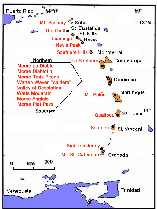
Although Mother Nature and Haiti have a very close relationship, where they share almost every natural hazard known to man, from earthquakes to tsunamis as I have covered before, Haiti although being near several subduction zones on the Caribbean plate, has not actually had volcanic activity for millions of years. The entire island of Hispaniola, that Haiti shares with the Dominican Republic, has no active volcanoes. However, as I said before, being near so many subduction zones, the possibility of a volcano forming in the future is more than likely. Most of the volcanic activity that occurs on the Caribbean is in the Lesser Antilles, where as Hispaniola lies in the Greater Antilles as shown below.
Caribbean Islands political map
  Lesser Antilles Map

Sources:

Thursday, September 6, 2018

Haiti Seismicity and Disaster Prevention Status

Seismicity for the Hispaniola region for the time period 1900–2010. Dependent earthquakes (for example, aftershocks and foreshocks) are not shown. The earthquakes are grouped into three categories by depth (d) of hypocenter, and their magnitudes are indicated by the size of the symbols. 
      Following the 7.0 earthquake that hit Haiti in 2010, or the Goudougoudou as known by the local populace, the USGS stepped in to provide more support and set up the countries first ever national seismic network in Haiti. Also, more recently, the International Code Council, a nonprofit organization responsible for creating stronger buildings that can withstand sizable earthquakes, pledged to help the Haitian's with access to their plans and professionals to aid in the rebuilding process. However earthquakes are not the only natural hazard this country is vulnerable to, which complicates and draw out the reconstruction of this country.

Sources: 


Sunday, September 2, 2018

Haiti's Position on the Carrribean Plate

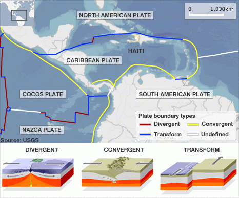
Haiti - Tectonic Plate Boundaries Disasters Famous Historical Events Geography STEM World History

Haiti sits on a border of the North American plate and Caribbean Plate. It nearest a transform plate boundary, so as the North American plate moves west, the Caribbean plate moves east which causes a lot of friction that is unleashed as high magnitude earthquakes. It is also due to the strike-slip fault systems that run through northern and southern Haiti. A recent example is of the 2010 Magnitude 7 earthquake that tore apart its nation's capital and killed over 90,000 people. 


Sources:

What are Natural Hazards, Disasters, and Catastrophes?


What are the differences between hazard, disaster, and catastrophe? Here's a list of what defines each event.

Natural Hazard:

Key Attributes:

  • a event and natural process.
  • a threat to human life and property.
  • the process itself is not a hazard, they only become due to humans use of land. 

Disaster:

Key Attributes:

  • hazardous event.
  • occurs over a limited time span.
  • defined area.

Criteria To Be Met(Minimum of One):

  1. 10 or more killed.
  2. 100 or more affected.
  3. State of Emergency declared.
  4. International assistance is requested.

Catastrophe:

Key Attributes:
  • Massive Disaster
  • Requires significant expenditure of money.
  • Long period of recovery(often years).